The Route
10/11/20246 min read
Voyage Length
In the period covered by this project, the average voyage length for a Botany Bay transport was 184 days, but averages can be misleading: times varied widely and fell over time. The Lady Juliana (1789) was the longest, at 309 days. The Albion, a storeship, had the shortest, at 107 days. The fastest voyage for a convict transport was the Matilda, a Third Fleet ship (1791), at 127 days. There is nothing in the records which suggests a preferred time of the year for sailing, not in this period at least.
Navigating the Atlantic
From a navigational point of view, the passage south through the Atlantic was not challenging. One of the First Fleet officers wrote that these waters were ‘too beaten to afford us anything new or interesting’. On that founding voyage, nine merchant ships sailed as a single convoy under the protection of two naval vessels, Sirius and Supply. The captain of the Sirius, Arthur Phillip, served as commodore of the fleet.
Phillip was responsible for the overall navigation of the fleet, and kept the ships in order by frequently issuing instructions through signals, and messages sent round the fleet by the Supply or one of his officers. But the masters were responsible for how their ships sailed, adjusting the trim as they grew accustomed to their vessels, replacing sails and spars as they were battered by storm, cleaning the ships’ sides as they were fouled by the sea. (For more detail, see this article on Phillip as Commodore of the First Fleet).
The Second Fleet (1790) consisted of three ships under the overall command of Donald Trail, the master of the largest ship, the Neptune, but on decisions about navigation, he was under the ultimate direction of Lieutenant John Shapcote, the naval agent appointed by the Navy Board, who sailed on that vessel.
The Third Fleet (1791) was a fleet in name only. Eight of the ten ships were organised into two divisions, each under a separate naval agent, but both convoys broke up and reassembled at different stages throughout the voyage. One of them parted from her convoy the first night at sea, and sailed on her own to NSW. The other two vessels, one with women and another with Irish convicts, also sailed alone. All of the other Botany Baymen in these early years sailed by themselves.
The masters used commercially published navigation guides which described the prevailing winds in various locations, how to negotiate unfamiliar straits and where to anchor in foreign harbours, but until the end of the century, these were not available for the coast of New South Wales or the western Pacific. The First Fleet captains carried Hawkesworth’s Voyages in the Southern Hemisphere and charts based on Cook’s 1770 expedition. A number of the journals published after the return of the First Fleet included charts and navigation guides, and these were periodically updated as ships arrived back from New South Wales. These ‘tracks’ and journals were particularly important for the homeward passage which was the least documented and most dangerous part of the voyage.
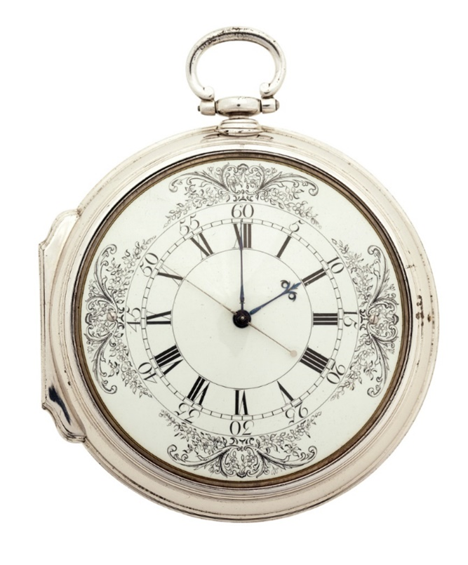
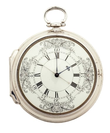
Mariners were still struggling with the challenge of ascertaining longitude. Captain Phillip used all three known methods on the First Fleet – dead reckoning, which estimated the distances travelled and courses sailed using the compass and a piece of board (or ‘log’) trailed behind the ship; lunar observations based on tables drawn up by the Astronomer Royal, Nevil Maskelyne; and the ‘new method’ which relied on solar observations to establish the distance from Greenwich using a chronometer. The Sirius carried a famous timekeeper known today as K1, on loan from the Board of Longitude. Cook had carried K1 on his first and third voyages and referred to it in his journals as ‘our trusty friend, the Watch’. But the manufacture of timekeepers had come a long way since 1769 and John Hunter carried a pocket watch made for him by Mr John Brockbank of Cornhill in the City of London which proved almost as accurate as K1.
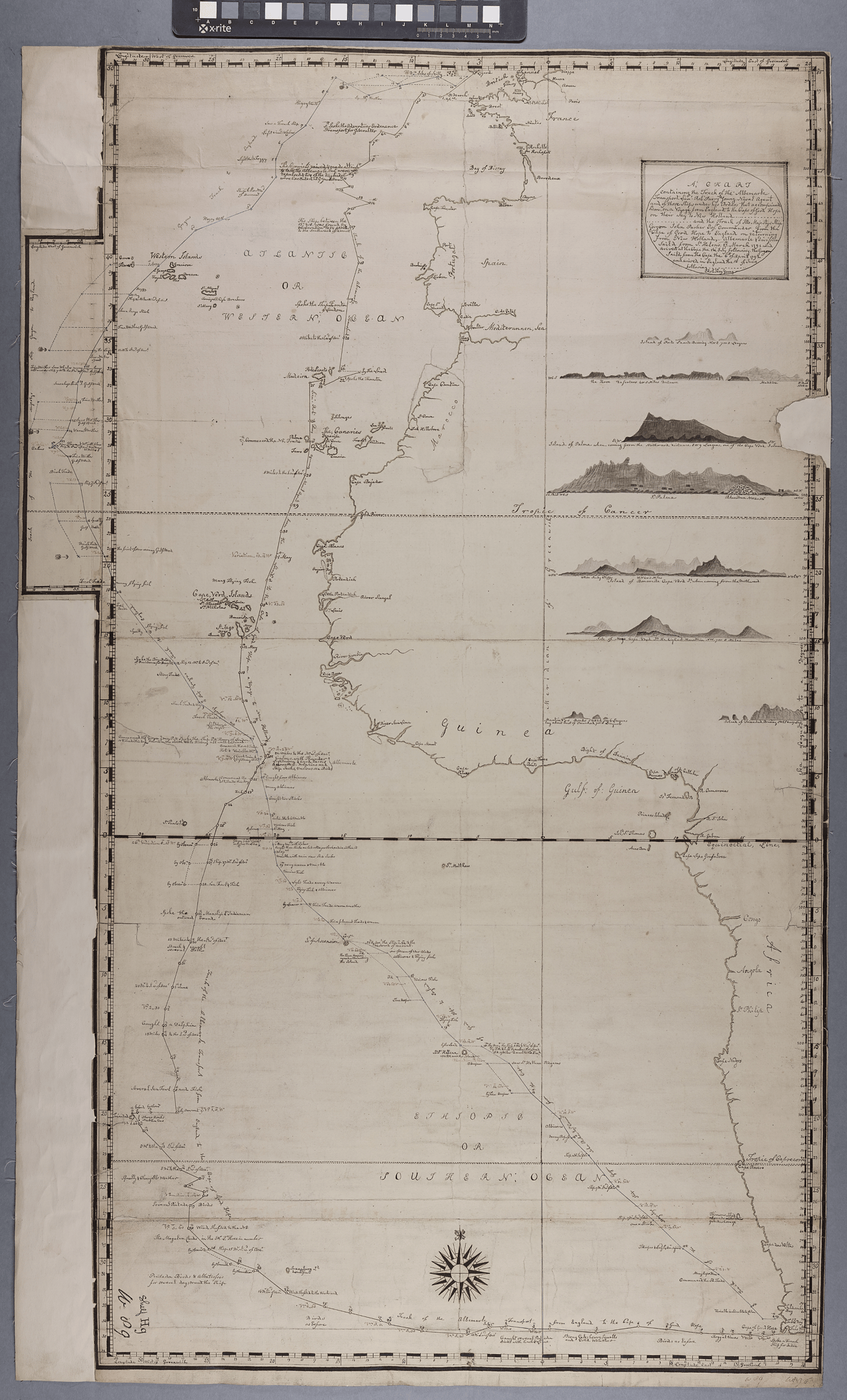
There are two known ‘tracks’ of the Atlantic for the convict ships. The first was published in 1787 before the First Fleet sailed and was based on the information available at that time. Contrary to what the track shows, Phillip touched at Rio de Janeiro and did not sail as far south in crossing the Southern Ocean. The other documents the voyage of the Albemarle (1791) and provides valuable insight into the passage of convict transports down through the Atlantic – although of course, they all differed in some ways.
The Atlantic Ports
On half of the 46 voyages of Botany Bay naval transports in this period, the ships made their way into Rio de Janeiro on their way south, and with eight of these, the ships also went into the Cape of Good Hope to refresh before launching into the Southern Ocean. Another 12 made their way to the Cape directly or touched briefly at one of the Spanish or Portuguese islands off the coast of Africa. Two went to St Helena, the East India Company’s base in the mid-Atlantic, and then the Cape. We have no details on three of the storeships, and it is possible that they sailed direct. Above all, it was the need for water which drove the convict ships into port: to run out of water at sea was to die. However, they also needed to obtain fresh fruit and vegetables for the convicts to reduce the effects of scurvy.
The Southern Ocean
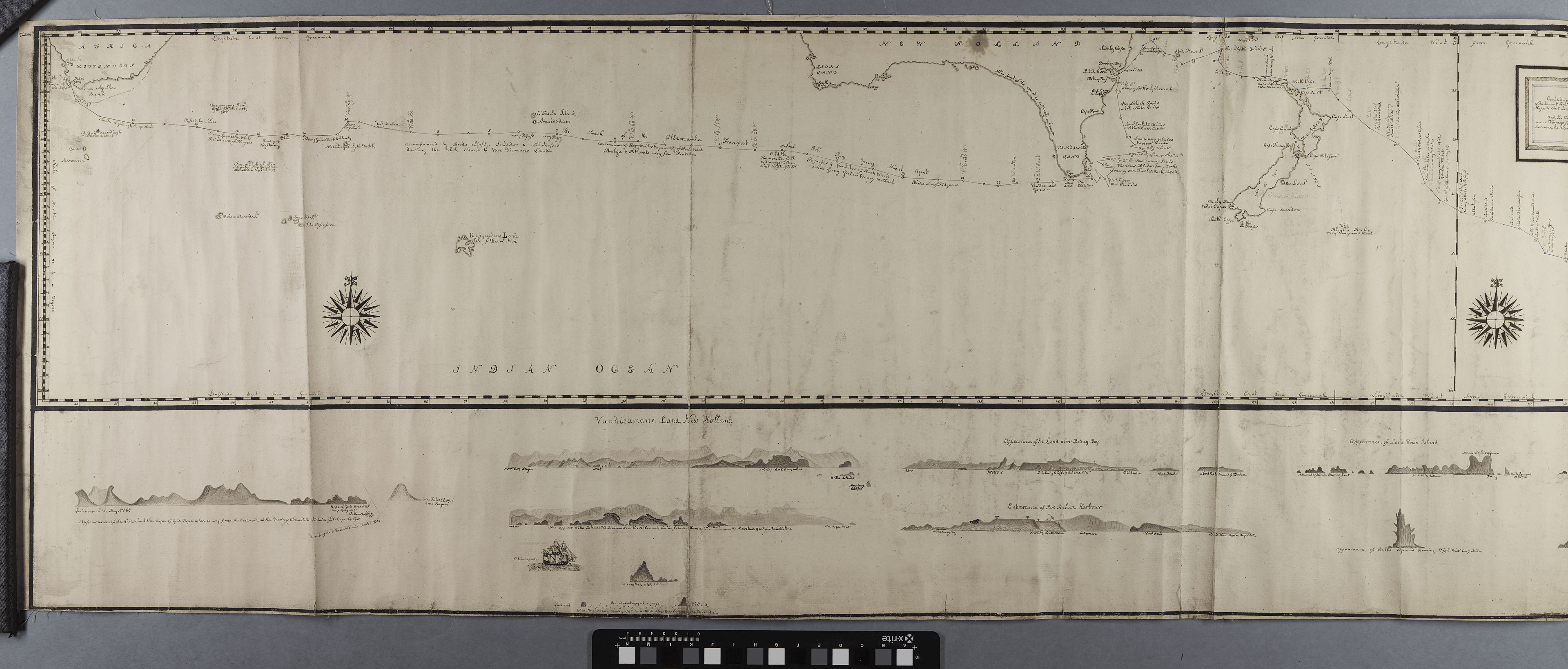
James Callam, a surgeon on the Supply (1787), described the voyage across the Southern Ocean from the Cape to Van Diemen’s Land (now Tasmania) as ‘a passage...through a sea but little known’. Over time, British mariners became more familiar with these waters, but it remained the most difficult part of the voyage. Ships crossed these waters at a latitude of around 40° South, dropping down to 44° or 45° to round the south-east cape of Van Diemen’s Land (now Tasmania). Bass Strait was not discovered until 1798, and it would not be used by the convict transports for another two years (see the Track of the Albemarle across the Southern Ocean).
In the final decade and a half of the 18th century, the voyage across this ‘barren and infertile’ expanse of water averaged 42 days, although times varied from as little as one month to as much as two. They could have had a faster passage by sailing further south into the ‘Roaring Forties’, but that would have been accompanied by stronger winds, higher seas and the risk of icebergs.
What distinguished this passage from the rest of the voyage was the immense swell, interrupted by cross seas. The journals speak of ‘prodigious seas’, ‘an irregular swell’, ‘a tremendous pitching and rolling’. It was in these waters that crew members were most likely to be crushed or thrown overboard by a lurch which caused the wheel to spin uncontrollably, a sail to suddenly collapse, or a rope to snap tight. The shock of a great wave placed immense strain on the timbers and would loosen the fastenings, although the sails could suffer almost as much damage in a calm. And in these waters, the convicts were often drenched when water poured down into the prison, and they might remain cold and wet for days on end.
Icebergs were one of the risks in the higher latitudes, particularly in the summer months, and the only Botany Baymen to be lost in these years on the outward voyage was HMS Guardian (1789), crippled by an island of ice two weeks after sailing from the Cape.
K1, the chronometer used on Australia’s First Fleet, on loan from the Board of Longitude (Larcum Kendall, K1 Chronometer, 1769, Royal Museums Greenwich, ZAA0038)

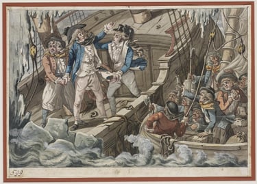
(poss. Robert Dighton), 'The Perilous Situation of the Guardian', mezzotint, c.1790, State Library of NSW, ML1112
Return voyages
Twenty of the contracted naval transports sailed to China after leaving NSW (or were meant to), where they would collect a cargo of tea on behalf of the East India Company and sail for home. Eight of them went to India for sugar or gruff goods, again on behalf of the Company, and another five went to India for a cargo on private account. Fourteen were whalers. Nine went home directly.
On these subsequent voyages, see newsletters on the Melvill Cup presented to the master of the Third Fleet ship which caught the first whale off the NSW coast, and the illicit trade carried on by some of the Third Fleet ships bound for India.
The waters of the south-west Pacific were little understood at the time, and a number of these ships made pioneering voyages. This is evident from the many reefs and islands named after the Botany Baymen of this early period: by way of example, the Marshall Islands in the mid-Pacific are named after the master of a First Fleet transport that was making its way to China, and Kiribati is a local pronunciation of Gilbert, the name of another First Fleet captain, who sailed with Marshall.
Contact us
Connect with us
Botany Baymen acknowledges the traditional custodians of country throughout Australia and respects their connection to land, water and community.
© Botany Baymen 2024. All rights reserved.
You may download, display, print and reproduce this content for your personal or non-commercial use but only in an unaltered form and with the copyright acknowledged.